Friday, November 24, 2023

Ishiteji Temple Part 1


Ishite-ji Temple is number 51 on the 88 temple Shikoku Pilgrimage known as Ohenro.


It is located near Dogo Onsen in Matsuyama City and is very popular with non-pilgrims as well as pilgrims.


My dilemma when it came time for this post was in how to choose from the almost 200 photos I took here, and decided to post about half of them but spread over 4 posts to make them manageable.


The temple was said to be founded by Gyoki in 728.


Later Kukai visited and changed it to be a Shingon temple.


At that time it was called Anyo-ji.


The Niomon, dating all the way back to 1318, is a National Treasure.


The honzon of Ishiteji is a Yakushi Nyorai.


The three-storey Pagoda is about the same age as the Niomon, and it is an Important Cultural Property.


Ishite-ji literally means "stone hand temple" and refers to the legend of Emon Saburo.


His story can be found in the post on Monjuin Temple that I had visited earlier in the day.


A small stone with an inscription is viewable in the temple treasure house is said to be the one found in the hand of the new-born baby.


The belfry, 3 photos above, also dates back to the early 14th century, though the bell is said to be a little older.


Many temples are quite, sedate, meditative places, conforming to a certain image of Buddhist temples.


Some, however, are noisy, colourful, and crowded, and Ishiteji is one of this katter kind.


There are numerous smaller halls and shrines scattered around, and an unusually large number of statues and paintings.


Part of the reason I took so many pictures was that the light was great, but also there werejust so many statues, many of which, in the upcoming posts, are most unusual


The previous temple was Hanta-ji Temple, number 50.


Next part click below

Thursday, November 23, 2023

Togitsu Town


One of the benefits of walking everywhere rather than using a faster method of travel is that you get to see things you would miss if you were in a hurry. You get to see many of the "boring places" thta you would normally avoid.


Heading north out of Nagasaki I had to pass through Togitsu. In essence it is really just a suburb of Nagasaki now and seems to be composed of the multitude of national chain businesses that cover the country.


However, the draincovers of the town showed an intriguing rock formation, a spire of rock with what appears to be a boulder perched precariously on top. The rock was previously known as Tsugi ishi bozu but is now more commonly referred to as Sabaku Sarakashi Ishi after a well known story.


According bto the story a mackerel seller was coming down the road with a basket full of mackerel to sell but when he saw the rock her decided it looked like it was about to fall off the spire of rock so he decide to wait until it did before passing on safely. The rock never did fall and all his fish rotted leading to a variety of "the moral of the story is....."


Not far from the rock was a very large mansion-type building. It is called a tea-house but was in fact one of the buildings making up a honjin, a residence for lords while they are travelling.


It is said that the hinjin was originally about twice the size of the remaining building. Unfortunateky it was not open to the public.


Nearby, Togitsu Town Hall had a statue in front that I felt must surely refer to a local myth or legend, but apparently not. It is titled "Fureai", which is a world of recent origin that refers to a kind of feeling of solidarity between different members of a community. It seems to have appeared in the 1970's after modern Japan's social structure had altered from what had been traditional.


The previous post in this series on day 64 of my first walk around Kyushu was the diary of day 63.

Thursday, November 16, 2023

Exploring the Kuniga Coast


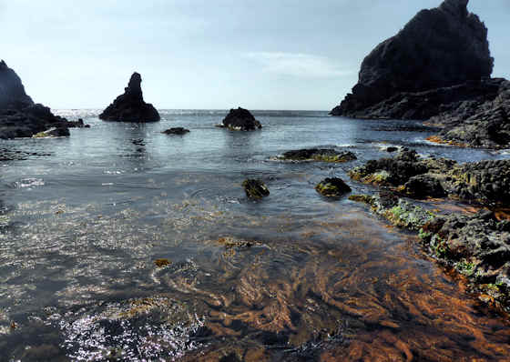
The Kuniga Coast is one of the prime attractions of Nishinoshima Island in the Oki Islands in the Sea of Japan off the coast of Shimane.


The Oki Islands have been a part of the Daisen-Oki National Park since 1936, but their popularity as a tourist destination increased when they became a UNESCO Global Geopark.


This section of the coast has the nickname Tenjokai, the "heavenly world" and many of the rock formations have evocative names like Kannon Rock, Elephant Nose Rock, Frog Rock etc.


At the far end of the coast is a natural arch named Tsutenkyo, the "Bridge to Heaven".


Beyond Tsutenkyo Arch are the Matengai Cliffs, rising 257 meters out of the sea they are among the tallest cliffs in all of Japan.


It is possible to view the coastline from the sea aboard a tour boat.


Better though is on foot especially at low tide when you cannot wander over the rocks and among the tidepools.


A footpath runs 2.3 kilometers along the coast and all the way up to the high point on top of the cliffs.


The schedule for boats trips...  available from April through to October.


Another unique sight on Nishinoshima is a "squid" shrine. An unusual sight on many of the Oki Islands are free-grazing horses and cattle. The previous post looked at the Kuniga Coast from a distance.


The other islands that make up the Oki Islands also have some impressive coastlines and perhaps the most famous is what is known as Candle Rock off the coast of Dogo.


I am putting up new posts covering all parts of Western Japan on an almost daily basis so if you would like to be sure of not missing anything please subscribe by leaving your email address in the comments below. It will not be made public.


I will be posting much more from the Oki Islands in the future...


Wednesday, November 15, 2023

Kyushu Pilgrimage Day 63 Obama to Nagasaki

Friday February 21st 2014


The sun may or may not be up as I head out of Obama and take the road north along the coast of Tachibana Bay. Looming over the town the massive Mount Unzen blocks any view of the sun until later in the morning. Looking back, plumes of steam rise from among the buildings, a signature of an onsen town. Tachibana Bay is calm and a little darker shade of blue than the sky. A thin line of even darker blue shows the far shore dividing the two expanses of blue.


After half an hour I am able to veer off the main road and take route 201 which was once a railway line. I come to a fork just outside the first fishing village. My map says to take the right fork which starts to rise. My natural inclination is to take the lower road that will hug the coast, but I defer to my map. The road climbs gently and gives a nice overview over the village below and then passes through a narrow tunnel with the distinctive horseshoe shape of a railway tunnel


Coming out of the tunnel I come upon what I presume to be a local TV station making a travel program. An older man and a younger woman are both dressed in khaki shorts and wearing pith helmets. I resist the urge to shout out “Doctor Livingstone I presume!”. With only a cameraman and a sound man as crew, I am presuming they are a low budget local TV show something along the lines of “Lets Explore Locally”, because the next section of the road is a minor tourist attraction known as the Green Tunnel. The road, formerly the railway track, passes through a narrow cutting and the trees growing above have spread their canopy over the narrow cutting thereby creating a “green tunnel”. The road curves around the mountainside passing through several more tunnels.


At several points, there are great views down onto fishing villages below and along the approaching north shore of the bay. The road starts to descend as slowly as it ascended and I end up in Chijiwa where the main road now heads west towards Nagasaki. I find a convenience store to stock up at and sit with a coffee and check my maps. I want to avoid the main road if I can. I find a coast road that literally runs between the cliffs and the sea. Perfect. There is no traffic save for the occasional k-truck. The road comes to an end at a small onsen located right on the beach. From here there is no easy way along the coast so I head inland and join up with the main road heading to Nagasaki.


The road is fairly busy and at first there is a sidewalk, but as it leaves the village the sidewalk ends but starts again at the next village. The road is windy and goes up and down, though never steeply, and because of this the view changes often. I am surprised by the number of love hotels around. It is still about 30 kilometers to Nagasaki, but it is about halfway between Nagasaki and Isahaya, so maybe they serve both populations. Its a fairly uneventful afternoon with a couple of shrine visits, but as the traffic increases closer to Nagasaki it become less enjoyable.


By late afternoon I have covered 30 kilometers but there is still more than 10 to go and I think maybe 40k is too much. In the summer, with the longish days, 40k is doable, but at this time of the year it is just too much so I check the timetable at the next bus stop and finding a bus imminent I decide to take it. Tomorrow I head home. This leg has seen me cover 190 kilometers, making a total of 1,710 kilometers in total.


The previous diary entry was Day 62 Over the Shimabara Peninsula.