Showing posts with label mountaintop. Show all posts

Wednesday, October 11, 2023

Views From Mount Futago


At 720 mteres, 2,364 ft, above sea level, Mount Futago is the highest point of the Kunisaki Peninsula in northern Oita, Kyushu.


On clear days, looking north past Homeshima Island, the coast of Honshu can be seen.


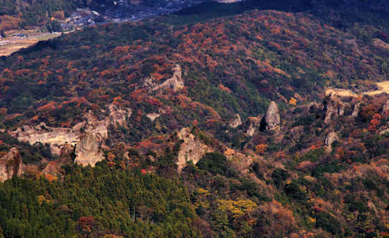
Like much of Japan, the Kunisaki Peninsula was formed by volcanic activity, and in essence is a lava plateau with a lava dome in its centre with multiple volcanoes. It was formed between 1 and 2 million years ago.


Erosion has left many cliffs and rock formations that can be seen from the top of Mount Futago.


The peninsula is roughly circular with Mount Futago at the centre. Radiating out are 28 valleys that became home to a unique religious culture known as Rokugo Manzan.


Rokugo Manzan incorporated Tendai Buddhism with Usa Hachiman "shinto" into a unique form of shugendo. Shugendo ascetics, known as yamabushi, were often attracted to such powerful geological features.


I had climbed up from Futago-ji Temple, now the head temple of Rokugo Manzan, located on the lower slopes of Mount Futago. I had spent all day walking up from near Kitsuki on the southern edge of the peninsula. My plan was to keep walking until I hit the ferry port on the northern coast.


Sunday, April 16, 2023

Mount Nosokodake Ishigaki

Mount Nosokodake Ishigaki


This is the view, looking north, from Mount Nosoko, sometimes referred to as Nosokodake, and also known as Nosoko Mape, on Ishigaki Island in Okinawa.


It is somewhat unusually shaped with a very steep peak.


Topped with a rocky outcropping, there are fantastic 360 degree views .


At 282 meters, it is not very high, but is still the second highest mountain on Ishigaki, after Mount Omoto, which at 525 meters in height is also the highest mountain in all of Okinawa.


A road goes up to about 200 meters altitude and from there, a sometimes steep trail takes you up to the apex.


The name Nosoko Mape comes from a local folk tale and song about a girl called Mape from nearby Kuroshima Island and her forced separation from her fiancee when half of the islanders were forced to move to the area around Nosodake in 1732 in order to "develop" the land to raise enough tax revenue to pay the Japanese Satsuma Clan who invaded Okinawa in the early 17th century.


The previous post in this series on Okinawa was on some of Ishigaki's lovely beaches.


Buy Ishigaki Bath Salts from Okinawa

Sunday, January 19, 2020

On top of Mount Kannomine


Mount Kannomine, 425 meters above the sea on Osaki Kamijima in the Inland Sea, is the highest poinbt on the island and where I chose to spend the night on the second day of my walk along the Akinada chain of islands. This link will take you to the other posts from  that walk and the views of sunset from Kannomine.


As well as an observation point that offers stunning views across the Inland Sea, there are two, small religious sites, a Shinti shrine and a Buddhist temple. The shrine is a branch of Ishizuchi Shrine, the famous shrine on top of Mount Ishizuchi, the highest point on Shikoku, and a center for yamabushi and tengu.


Like the shrine, the small temple was also a concrete structure, and it was a Yakushi-do. It had a nice. small Fudo Myo, but the big surprise was a wooden phallus.


Other than a couple of famous sites and shrines in some of the big cities, phalli are far less common than they used to be and it is always a joy to find them in remote spots like this.